File:RamseyBreweries OS1868.jpg
Jump to navigation
Jump to search

Size of this preview: 320 × 130 pixels. Other resolution: 1,036 × 421 pixels.
Original file (1,036 × 421 pixels, file size: 92 KB, MIME type: image/jpeg)
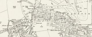
Ordnance Survey extract from 1868. Two breweries can be seen: (1) The Royal Albert Brewery on Tower Street; (2) A second (unnamed) brewery on West Street. Also Maltings on Lezayre Road. The image is reproduced with the permission of the National Library of Scotland (http://maps.nls.uk/index.html)
File history
Click on a date/time to view the file as it appeared at that time.
| Date/Time | Thumbnail | Dimensions | User | Comment | |
|---|---|---|---|---|---|
| current | 16:12, 28 July 2019 | 1,036 × 421 (92 KB) | SteveP (talk | contribs) | File uploaded with MsUpload |
You cannot overwrite this file.
File usage
The following page uses this file: