Notting Hill Brewery Co Ltd: Difference between revisions
Jump to navigation
Jump to search
No edit summary |
No edit summary |
||
| Line 1: | Line 1: | ||
[[file:Notting Hill ad 1899.jpg|thumb]] | [[file:Notting Hill ad 1899.jpg|thumb]] | ||
[[File:Notting Hill Bry aa.jpg|thumb]] | |||
[[File:Notting Hill.jpg|thumb]] | |||
<big>'''Notting Hill Brewery Co. Ltd''', ''243 Portland Road, London W11.''</big> | |||
In 1876 run by Charles Clarke. In receivership October 1891. Registered as above 1905. | Established c.1855 by W L & H Woodman and known as the '''Kensington Park Brewery''' then the Griffin Brewery. In 1876 run by Charles Clarke. In receivership October 1891. Registered as above 1905. | ||
Brewing ceased in 1920 and 80 of the tied houses were sold to [[Whitbread & Co. Ltd]], a number of these being resold to Charrington & Co. Ltd. | Brewing ceased in 1920 and 80 of the tied houses were sold to [[Whitbread & Co. Ltd]], a number of these being resold to Charrington & Co. Ltd. The brewery was demolished in about 1930 and the site redeveloped as an apartment block. | ||
Brewery | * '''[[List of Notting Hill Brewery Co Ltd pubs]]''' | ||
''' | '''Maps of the Brewery''' | ||
<gallery> | <gallery> | ||
File: | File:NottingHillBry_OS1871.jpg|Ordnance Survey extract from 1871. Reproduced with the permission of the National Library of Scotland (http://maps.nls.uk/index.html) | ||
File: | File:NottingHillBry_OS1895.jpg|Ordnance Survey extract from 1895. Reproduced with the permission of the National Library of Scotland (http://maps.nls.uk/index.html) | ||
File:NottingHillBry_OS1914.jpg|Ordnance Survey extract from 1914. Reproduced with the permission of the National Library of Scotland (http://maps.nls.uk/index.html) | |||
</gallery> | </gallery> | ||
'''From the BBC TV series. Courtesy Keith Langridge.''' | '''From the BBC TV series. Courtesy Keith Langridge.''' | ||
<gallery> | <gallery> | ||
File:Notting Hill Bry BBC TV K Langridge (1).JPG|An old map of London, 19th century as made by the Salvation Army originator, Lord Boothby. | |||
File:Notting Hill Bry BBC TV K Langridge (2).JPG | |||
File:Notting Hill Bry BBC TV K Langridge (3).JPG | File:Notting Hill Bry BBC TV K Langridge (3).JPG | ||
File:Notting Hill Bry BBC TV K Langridge (4).JPG | File:Notting Hill Bry BBC TV K Langridge (4).JPG | ||
File:Notting Hill Bry BBC TV K Langridge (5).JPG | File:Notting Hill Bry BBC TV K Langridge (5).JPG | ||
</gallery> | </gallery> | ||
[[Category:Greater London]] | [[Category:Greater London]] | ||
Latest revision as of 11:53, 20 February 2026


Notting Hill Brewery Co. Ltd, 243 Portland Road, London W11.
Established c.1855 by W L & H Woodman and known as the Kensington Park Brewery then the Griffin Brewery. In 1876 run by Charles Clarke. In receivership October 1891. Registered as above 1905.
Brewing ceased in 1920 and 80 of the tied houses were sold to Whitbread & Co. Ltd, a number of these being resold to Charrington & Co. Ltd. The brewery was demolished in about 1930 and the site redeveloped as an apartment block.
Maps of the Brewery
-
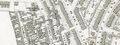 Ordnance Survey extract from 1871. Reproduced with the permission of the National Library of Scotland (http://maps.nls.uk/index.html)
 -
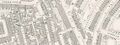 Ordnance Survey extract from 1895. Reproduced with the permission of the National Library of Scotland (http://maps.nls.uk/index.html)
 -
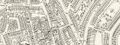 Ordnance Survey extract from 1914. Reproduced with the permission of the National Library of Scotland (http://maps.nls.uk/index.html)
From the BBC TV series. Courtesy Keith Langridge.
-
 An old map of London, 19th century as made by the Salvation Army originator, Lord Boothby.
 -

-

-

-

.JPG)
.JPG)
.JPG)
.JPG)
.JPG)