Witham Brewery (Lincolnshire): Difference between revisions
Jump to navigation
Jump to search
No edit summary |
No edit summary |
||
| Line 4: | Line 4: | ||
'''Thomas Sharpe (Exors of)''' recorded here in 1912. | '''Thomas Sharpe (Exors of)''' recorded here in 1912. | ||
<gallery> | <gallery> | ||
File:WithamBrewery1_OS1888.jpg | File:WithamBrewery1_OS1888.jpg|Ordnance Survey extract from 1888. Reproduced with the permission of the National Library of Scotland (http://maps.nls.uk/index.html) | ||
File:WithamBrewery2_OS1947.jpg | |||
File:WithamBrewery2_OS1947.jpg|Ordnance Survey extract from 1947. Reproduced with the permission of the National Library of Scotland (http://maps.nls.uk/index.html) | |||
</gallery> | </gallery> | ||
[[Category:Lincolnshire]] | [[Category:Lincolnshire]] | ||
Revision as of 13:04, 11 July 2019
Witham Brewery, North Forty Foot Bank, Holland Fen, Lincolnshire LN4 4QQ
(Some early maps show "Kirton Fen".) Witham Brewery is shown on OS maps from 1888, and is still shown on some modern maps, although the premises is now an isolated dwellinghouse.
Thomas Sharpe (Exors of) recorded here in 1912.
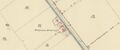
Ordnance Survey extract from 1888. Reproduced with the permission of the National Library of Scotland (http://maps.nls.uk/index.html)
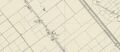
Ordnance Survey extract from 1947. Reproduced with the permission of the National Library of Scotland (http://maps.nls.uk/index.html)

