Grove Brewery (Hunslet): Difference between revisions
Jump to navigation
Jump to search
(Created page with "<big>'''Grove Brewery''', ''Pepper Lane, Hunslet, Leeds, West Yorkshire''</big> category: West Yorkshire") |
No edit summary |
||
| Line 1: | Line 1: | ||
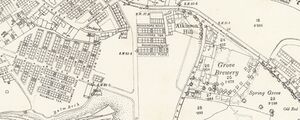
[[File:LeedsGroveBrewery_OS1890.jpg|thumb|Ordnance Survey extract from 1890. Reproduced with the permission of the National Library of Scotland (http://maps.nls.uk/index.html)]] | |||
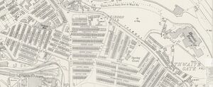
[[File:LeedsGroveBrewery_OS1905.jpg|thumb|Ordnance Survey extract from 1905. Reproduced with the permission of the National Library of Scotland (http://maps.nls.uk/index.html)]] | |||
<big>'''Grove Brewery''', ''Pepper Lane, Hunslet, Leeds, West Yorkshire''</big> | <big>'''Grove Brewery''', ''Pepper Lane, Hunslet, Leeds, West Yorkshire''</big> | ||
William Henry Collins Ale & Porter Brewer, recorded in 1837. | |||
Insolvent 1841. | |||
The brewery is shown on the Ordnance Survey map in 1890, but by 1905 it had been replaced with back-to-back housing. | |||
[[category: West Yorkshire]] | [[category: West Yorkshire]] | ||
Revision as of 13:56, 22 May 2020

Ordnance Survey extract from 1890. Reproduced with the permission of the National Library of Scotland (http://maps.nls.uk/index.html)

Ordnance Survey extract from 1905. Reproduced with the permission of the National Library of Scotland (http://maps.nls.uk/index.html)
Grove Brewery, Pepper Lane, Hunslet, Leeds, West Yorkshire
William Henry Collins Ale & Porter Brewer, recorded in 1837.
Insolvent 1841.
The brewery is shown on the Ordnance Survey map in 1890, but by 1905 it had been replaced with back-to-back housing.