George Pacy (Worthing): Difference between revisions
Jump to navigation
Jump to search
No edit summary |
No edit summary |
||
| (10 intermediate revisions by 2 users not shown) | |||
| Line 1: | Line 1: | ||
[[Image: | [[Image:newstreetadvert.jpg|thumb]] | ||
[[Image:Pacy Worthing.jpg |thumb]] | [[Image:Pacy Worthing.jpg|thumb]] | ||
<big>'''George Pacy | |||
<big>'''George Pacy''', ''New Street Brewery, 13 New Street, Worthing, West Sussex.''</big> | |||
James Carter was brewing here by 1860. The census of 1861 shows a new owner, James Slaughter and his wife Ann. By 1871, George Pacy owned the pub and brewery. | |||
George died May 1931 and son Sydney carried on. Brewed draught beer mainly for their public house and the retail trade. | George died May 1931 and son Sydney carried on. Brewed draught beer mainly for their public house and the retail trade. | ||
Acquired by the [[Stockwell Brewery Ltd]] | Acquired by the [[Stockwell Brewery Co. Ltd]] of London 1947. The pub was later a Tamplin's house. | ||
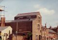
The tower brewery at the rear of the former pub still stands, facing Augusta Place. | |||
<gallery> | |||
Worthing Pacey F5894.jpg | |||
WorthingNewStreet01.jpg|Courtesy worthingpubs.com | |||
WorthingNewStreet02.jpg|Courtesy worthingpubs.com | |||
WorthingNewStreet_OS1909.jpg|An Ordnance Survey extract from 1909. Reproduced with the permission of the National Library of Scotland (http://maps.nls.uk/index.html) | |||
</gallery> | |||
[[Category:West Sussex]] | |||
Latest revision as of 12:29, 6 April 2020


George Pacy, New Street Brewery, 13 New Street, Worthing, West Sussex.
James Carter was brewing here by 1860. The census of 1861 shows a new owner, James Slaughter and his wife Ann. By 1871, George Pacy owned the pub and brewery.
George died May 1931 and son Sydney carried on. Brewed draught beer mainly for their public house and the retail trade.
Acquired by the Stockwell Brewery Co. Ltd of London 1947. The pub was later a Tamplin's house.
The tower brewery at the rear of the former pub still stands, facing Augusta Place.
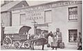
Courtesy worthingpubs.com
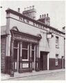
Courtesy worthingpubs.com
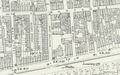
An Ordnance Survey extract from 1909. Reproduced with the permission of the National Library of Scotland (http://maps.nls.uk/index.html)


