Thomas Mansfield (Acocks Green): Difference between revisions
Jump to navigation
Jump to search
No edit summary |
No edit summary |
||
| Line 1: | Line 1: | ||
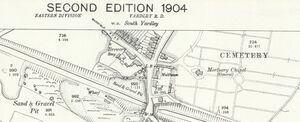
[[File:AcocksGreenThosMansfield_OS1904.jpg|thumb|Ordnance Survey extract from 1904. Reproduced with the permission of the National Library of Scotland (http://maps.nls.uk/index.html) | [[File:AcocksGreenThosMansfield_OS1904.jpg|thumb|Ordnance Survey extract from 1904. Reproduced with the permission of the National Library of Scotland (http://maps.nls.uk/index.html)]] | ||
<big>'''Thomas & Miss A M Mansfield''', ''Mansfield Road, Acocks Green, Birmingham, West Midlands''</big> | <big>'''Thomas & Miss A M Mansfield''', ''Mansfield Road, Acocks Green, Birmingham, West Midlands''</big> | ||
Revision as of 11:55, 28 October 2020

Ordnance Survey extract from 1904. Reproduced with the permission of the National Library of Scotland (http://maps.nls.uk/index.html)
Thomas & Miss A M Mansfield, Mansfield Road, Acocks Green, Birmingham, West Midlands
Also shown as Yardley Brewery. Mrs Mary Ann Mansfield, a widow, ran Pinfold Farm with her family at Mansfield Road / Yardley Road in the latter half of the 19th century. In the 1911 Census, her sons Thomas and William, and daughter Ann Maria were shown as brewers; there is also evidence of a beerhouse on the site. The brewery is shown on Ordnance Survey maps for 1904 and 1913, and in 1904 a 'Malthouse' is also shown opposite, on Yardley Road. Brewery still recorded in 1923.
The surviving buildings in September 2020 (Mike Brown)

